Using Docker
- Install Docker
- Clone the repository
git clone https://github.com/versx/NodeTileserverCache - Change directory into cloned folder
cp NodeTileserverCache - Create a new folder to store the
.mbtilesfile in and change directories to it:mkdir TileServer && cd TileServer - Get the download command from https://openmaptiles.com/downloads/ for your region.
- Download the file using the wget from OpenMapTiles website.
- Rename downloaded file to end in
.mbtilesextension if the name is incorrect. - Change one folder back into the root NodeTileserverCache project folder where the docker-compose.yml file is located:
cd .. - Copy example.env to .env
cp src/example.env src/.env - Fill out
src/.envenvironment config (defaults are fine) - Start and attach to logs:
docker-compose up -d && docker-compose logs -f
Manually
- Install tileserver-gl either using docker or on the system itself.
- Get Download command from https://openmaptiles.org/downloads/ for your region.
- Download the file using wget.
- Rename file to end in .mbtiles if it got named incorrectly.
- Launch tileserver-gl and provide .mbtiles file in launch parameters.
- Install ImageMagick
sudo apt-get install -y imagemagick && sudo cp /usr/bin/convert /usr/local/bin - Clone repository
git clone https://github.com/versx/NodeTileserverCache - Change directory to cloned folder
cd NodeTileserverCache - Install dependencies, run
npm install - Install Typescript, run
sudo npm install -g typescript - Copy example.env to .env
cp src/example.env src/.env - Fill out
src/.envenvironment config (defaults are fine) - Start
npm run start
- Tiles:
GET tile/{style}/{z}/{x}/{y}/{scale}/{format}
- StaticMap:
GET /static/{style}/{lat}/{lon}/{zoom}/{width}/{height}/{scale}/{format}?markers=[{}]&polygons=[{}](StaticMap url query)POST /staticmap(StaticMap Object in JSON Format as POST body)GET /staticmap(SaticMap Object in URL Parameters. Markers and Polygons need to be URL-encoded)GET /staticmap/:template(Template Enviroment parsed from URL Parameters. Parameters ending injsonwill be parsed as json.GET /staticmap/pregenerated/:id(Get image from pregenerated map. Use GET or POST to /staticmap with pregenerate=true as URL Parameter to get pregenerate the map)
- MutliStaticMap:
POST /multistaticmap(MultiStaticMap Object in JSON Format as POST body)GET /multistaticmap/:template(Template Enviroment parsed from URL Parameters. Parameters ending injsonwill be parsed as json.GET /multistaticmap/pregenerated/:id(Get image from pregenerated map. Use GET or POST to /multistaticmap with pregenerate=true as URL Parameter to get pregenerate the map)
Get a list of styles by visiting /styles
Checkout https://tileserver.readthedocs.io for a guide on how to add more styles.
StaticMap route accepts an url-ecoded JSON (check bellow) on markers query parameter.
Example:
[
  {
    "url": "Marker Image URL",
    "height": 50,
    "width": 50,
    "x_offset": 0,
    "y_offset": 0,
    "latitude": 10.0,
    "longitude": 10.0
 },
 …
]
StaticMap route accepts a StaticMap Object JSON Object as POST body: Example:
{
  "style": string (check available styles at /styles),
  "latitude": double,
  "longitude": double,
  "zoom": int,
  "width": int,
  "height": int,
  "scale": int,
  "format": string? (png, jpg, ...),
  "bearing": double?,
  "pitch": double?,
  "markers": [Marker]?,
  "polygons": [Geofence]?,
  "circles": [Circle]?,
  "watermarks": [Watermark]?
}
MultiStaticMap route accepts a MultiStaticMap JSON Object as POST Body: Example:
{
  "grid": [
    {
      "direction": string (always "First"),
      "maps": [
        {
          "direction": string (always "First"),
          "map": StaticMap
        }, {
          "direction": string ("Right", or "Bottom"),
          "map": StaticMap
        },
        ...
      ]
    }, {
      "direction": string ("Right", or "Bottom"),
      "maps": [
        {
          "direction": string (always "First"),
          "map": StaticMap
        }, {
          "direction": string ("Right", or "Bottom"),
          "map": StaticMap
        },
        ...
      ]
    },
    ...
  ]
}
Marker JSON used in StaticMap: Example:
{
  "url": string,
  "height": int,
  "width": int,
  "x_offset": int,
  "y_offset": int,
  "latitude": double,
  "longitude": double
}
Polygon JSON used in StaticMap: Example:
{
  "fill_color": string (imagemagick color string),
  "stroke_color": string (imagemagick color string),
  "stroke_width": int,
  "path": [
    [double (lat), double (lon)],
    [double, double],
    ...
  ]
}
Circle JSON used in StaticMap: Example:
{
  "radius": int,
  "latitude": double,
  "longitude": double,
  "fill_color": string, (imagemagick color string)
  "stroke_color": string, (imagemagick color string)
  "stroke_width": int
}
Watermark JSON used in StaticMap: Example:
{
  "text": string,
  "fill_color": string, (imagemagick color string)
  "stroke_color": string, (imagemagick color string)
  "stroke_width": int,
  "size": int,
  "location": string, (imagemagick gravity keyword: NorthWest, North, NorthEast, West, Center, East, SouthWest, South, SouthEast)
  "font": string (available font on system)
}https://tileserverurl/tile/klokantech-basic/{z}/{x}/{y}/2/png
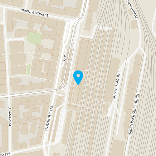
Pregenerate: GET https://tileserverurl/staticmap?style=klokantech-basic&latitude=47.263416&longitude=11.400512&zoom=17&width=500&height=500&scale=2&pregenerate=true
Returns: id
View: GET https://tileserverurl/staticmap/pregenerated/{id}
POST https://tileserverurl/staticmap
{
    "style": "klokantech-basic",
    "latitude": 47.263416,
    "longitude": 11.400512,
    "zoom": 17,
    "width": 500,
    "height": 500,
    "scale": 1,
    "markers": [
        {
            "url": "https://upload.wikimedia.org/wikipedia/commons/thumb/8/88/Map_marker.svg/1200px-Map_marker.svg.png",
            "latitude": 47.263416,
            "longitude": 11.400512,
            "width": 50,
            "height": 50
        }
    ]
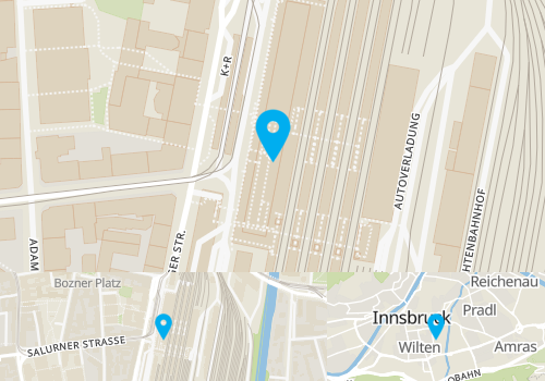
}POST https://tileserverurl/multistaticmap
{
    "grid": [
        {
            "direction": "First",
            "maps": [
                {
                    "direction": "First",
                    "map": {
                        "style": "klokantech-basic",
                        "latitude": 47.263416,
                        "longitude": 11.400512,
                        "zoom": 17,
                        "width": 500,
                        "height": 250,
                        "scale": 1,
                        "markers": [
                            {
                                "url": "https://upload.wikimedia.org/wikipedia/commons/thumb/8/88/Map_marker.svg/1200px-Map_marker.svg.png",
                                "latitude": 47.263416,
                                "longitude": 11.400512,
                                "width": 50,
                                "height": 50
                            }
                        ]
                    }
                }
            ]
        },
        {
            "direction": "Bottom",
            "maps": [
                {
                    "direction": "First",
                    "map": {
                        "style": "klokantech-basic",
                        "latitude": 47.263416,
                        "longitude": 11.400512,
                        "zoom": 15,
                        "width": 300,
                        "height": 100,
                        "scale": 1,
                        "markers": [
                            {
                                "url": "https://upload.wikimedia.org/wikipedia/commons/thumb/8/88/Map_marker.svg/1200px-Map_marker.svg.png",
                                "latitude": 47.263416,
                                "longitude": 11.400512,
                                "width": 25,
                                "height": 25
                            }
                        ]
                    }
                },
                {
                    "direction": "Right",
                    "map": {
                        "style": "klokantech-basic",
                        "latitude": 47.263416,
                        "longitude": 11.400512,
                        "zoom": 12,
                        "width": 200,
                        "height": 100,
                        "scale": 1,
                        "markers": [
                            {
                                "url": "https://upload.wikimedia.org/wikipedia/commons/thumb/8/88/Map_marker.svg/1200px-Map_marker.svg.png",
                                "latitude": 47.263416,
                                "longitude": 11.400512,
                                "width": 25,
                                "height": 25
                            }
                        ]
                    }
                }
            ]
        }
    ]
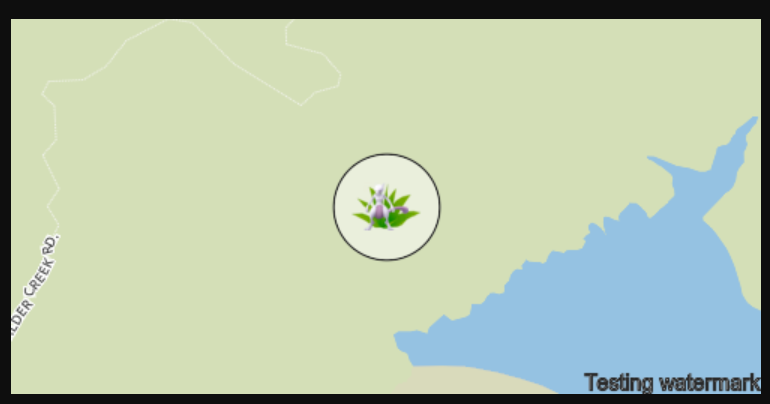
}pokemon.json file in Templates directory (uses EJS as Templating Engine):
{
    "style": "klokantech-basic",
    "latitude": <%= lat %>,
    "longitude": <%= lon %>,
    "zoom": 15,
    "width": 500,
    "height": 250,
    "scale": 1,
    "markers": [{
        "url": "https://raw.githubusercontent.com/Mygod/pokicons/master/v2/<%= id %><% if (form) { %>-f<%= form %><% } %>.png",
        "latitude": <%= lat %>,
        "longitude": <%= lon %>,
        "width": 50,
        "height": 50
    }],
    "circles": [{
        "latitude": <%= lat %>,
        "longitude": <%= lon %>,
        "radius": 25,
        "fill_color": "rgba(100.0%, 100.0%, 100.0%, 0.5)",
        "stroke_color": "rgb(45, 45, 45)",
        "stroke_width": 1
    }],
    "watermarks": [{
        "text": "Testing watermark",
        "fill_color": "rgba(250, 250, 250, 0.3)",
        "stroke_color": "white",
        "stroke_width": 1,
        "size": 14,
        "location": "center",
        "font": "Arial"
    }]
}
GET https://tileserverurl/staticmap/pokemon.json?id=201&lat=47.263416&lon=11.400512&form=5

{
   "lat": 1.0,
   "lon": 1.0,
   "id": 3,
   "form": 0,
   "gyms": [
     { "lat": 1.0, "lon": 1.0, "team": 1 },
     { "lat": 2.0, "lon": 2.0, "team": 3 },
     ...
   ],
   "stops": [
     { "lat": 1.1, "lon": 1.1 },
     { "lat": 2.1, "lon": 2.1 },
     ...
   ]
}- Pass through
.envconfig todocker-compose.ymlenvironment section


