Home
BASEline is a set of tools designed to help skydivers and BASE jumpers improve wingsuit flight performance. BASEline consists of two parts:
- BASEline Flight Computer is an android app that uses phone sensors to provide audible and visual feedback on speed and position, as well as logging data for later analysis.
- https://baseline.ws is an interactive website to help process and analyze flight data.
BASEline is provided free of charge, because wingsuiting is fucking dangerous, and everyone should have access to the best tools.
BASEline Flight Computer uses a combination of sensors in your phone to determine its position and speed. Sensors used include: GPS, barometric altimeter, gyroscope, accelerometer, and compass. Results can vary dramatically from one phone to another.
It is recommended you use BASEline on phones with a barometer, since it provides an additional source of height information that is generally more reliable than GPS. Most android phones today already include a barometer. However, be aware that high/low pressure areas around the body can affect altitude readings. Higher pressure inside a wingsuit can also cause errors in altitude reading.
It is critical that your GPS receiver has a clear view of the sky in order to acquire GPS signals. The back of your helmet is generally a good place to put your GPS receiver.
Your phone's built in GPS is usually not a good source of data. The GPS receivers in most phones update their location only once per second (1Hz). The antennas are usually not very good, and it is difficult to mount a phone on the back of your helmet.
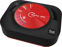
It is strongly recommended that you use an external bluetooth GPS receiver such as the SkyPro XGPS160. These units give much better quality data and with a higher sampling rate (10Hz). Because they are smaller and wireless, they are easier to mount in a good location.
BASEline is compatible with FlySight. However, FlySight does not have wireless connections, so it is necessary to use a USB cable to copy files from your FlySight.
You can read FlySight files directly from the BASEline app if you have a USB On-The-Go (OTG) cable. You need a cable that goes from male Mini-USB connector for the FlySight, to your phone (usually USB-C or Micro-USB).
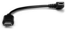
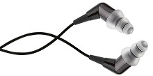
Figure out how you are going to configure your gear with BASEline while on the ground. There are many options for where to put your phone, and how to route audio to your ears. Audio can be difficult to hear without a full face helmet and good quality headphones. Noise isolating earphones work best.
While still on the ground, open the BASEline Flight Computer app. From the home screen, long-click the Audible button to open the audible settings.

The audible will speak to you while in flight. Current audible modes include:
- Horizontal Speed
- Vertical Speed
- Total Speed
- Glide Ratio
- Navigation
The audible will only say a measurement if it falls between the min and max settings. The speech interval controls how often the audible should read a measurement out loud. The speech rate controls how fast the speech-to-text engine should speak.
Navigation mode is intended to help navigate to a pre-determined home location. From the home screen, click "nav", and drag the map so that it is centered on your target location. Once it is centered in the cross hairs on the map, click the pin icon to set the home location. Once the home location is set, navigation mode will read the distance and bearing to the home location, relative to your current location and flight path.
Before exiting, open the BASEline Flight Computer app. From the home screen, long-press the Audible button to enable the audible.
The app should then speak the measurement mode, and begin reading data.
Experiment with different body positions and angles of attack. Using this feedback loop, you can learn to optimize your speed and glide ratio.
You can use the BASEline Flight Computer app to log flight data using sensors in your phone. When you click record, BASEline will begin logging all GPS, altimeter, accelerometer, and other sensor data.
When you click stop, track data will be written to a CSV file on your phone.

If you are signed in to your BASEline account, tracks will automatically upload when finished recording. If you are not signed in, or signal is unavailable, you can upload the track later from the tracks screen.


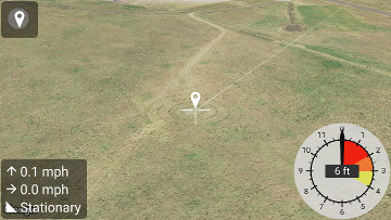
Navigation mode provides visual feedback on speed and position. The main view is a map which will automatically center on your location. The bottom left panel lists altitude above ground level (AGL), climb rate, ground speed, and glide ratio. The bottom right has an analog-style altimeter.
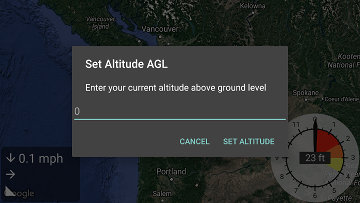
BASEline Flight Computer uses a combination of GPS and barometer readings to determine your altitude. GPS altitude data is always measured above mean sea level (AMSL). Barometer can only read air pressure, and therefore can only give relative altitude changes. For skydiving and BASE jumping, the most important altitude is how high you are above ground level.
BASEline Flight Computer defaults to setting the ground level to zero when the app is first started. However, you can adjust the ground level setting by long-clicking the analog altimeter. This will give you the option to manually set the altitude AGL.
Navigation mode supports setting a "home" location, which can be useful for navigating to a particular landing zone. Once a home location is set, BASEline will draw a white line from your current location to the home location. You can set the home location by dragging the map. Once you start dragging, you will see a target will in the center, and a button to drop a pin on the home location.
Navigation mode also includes a digital version of the accuracy trick. BASEline uses your current altitude AGL, descent rate, ground speed, and bearing to determine your projected landing location. When BASEline can determine your projected landing zone, it will draw a red target, with a red line from your current position to the projected landing zone.
If you line up the projected landing location with the home location, it is possible to land very accurately. Note that projected landing zone assumes steady-state flight, with no changes in flight configuration or wind layers.
In order to analyze tracks they need to be synced with baseline.ws. In the BASEline app, click tracks, verify that you are signed in, click on a synced track.
Click "details" to open the track in a web browser on baseline.ws.
Click "map" to open the track in Google Earth or Google Maps, depending on what apps you have installed.
